Showing posts with label Africa. Show all posts

Thursday, 10 December 2015

The Breadbasket of Tanzania

The focus of this blog post is policy documentation from the International Union for Conservation of Nature (IUCN) Water and Nature Initiative (WANI) case study, looking at the Pangani River Basin (PRB) in North-East Tanzania (Welling et al 2011). The basin covers an area of 56,300 km2 (95%) in Tanzania, with 4,880 km2 (5%) of this situated within Kenya (Welling et al 2011). In order to improve management of the limited water resources available for the basin's 3.4 million inhabitants and gather technical information, with an overarching aim of strengthening Integrated Water Resources Management (IWRM), the Pangani River Basin Management Project (PRBMP) was set up in 2002.
A map of the Pangani River Basin (Source: Pangani River Basin, Tanzania Report)

Fertile soils and abundant rainfall mean this basin has been referred to as the 'breadbasket of Tanzania' (Welling et al 2011). In 2011, it was estimated by the WANI case study that ~55,000ha of the basin was being intensely irrigated with inefficient furrow irrigation. As well as irrigation, water from the multiple rivers constituting the basin serve several hydroelectric power (HEP) stations, collectively providing 17% of Tanzania's electricity demand (Welling et al 2011). Together, irrigation and HEP use nearly 90% of surface flow in the Pangani (Barchiesi et al 2011).

Problems within the basin

The basin is already defined as water-stressed (<1200m3 water per person, per year), and thus climate change is exacerbating the problem of there not being enough water supply to meet demands (PRBMP 2015; Welling et al 2011). We saw in my last post that Mount Kilimanjaro's glaciers are receding at dramatic rates due to impacts of climate change, and this is impacting flows in the nearby PRB (IUCN 2011). Flows which used to be several hundreds of metres per second have diminished to below 40m3 (Welling et al 2011; IUCN 2011)! The combined effects of 1.8-3.6°C temperature rise in Tanzania, intensified and unpredictable precipitation patterns, and increased evaporation and evapotranspiration are expected to cause a 6-10% decline in annual basin flows (PRBMP 2015). The reduction in river flow has already caused seawater intrusion 20km upstream from the estuary (PRBMP 2015) and thus future additional reduction will put livelihoods, industry and the economy of Tanzania at stake.

A warming world, with urbanisation, population growth, intensified agriculture, and rising energy demands have all led to increased competition and overexploitation of water resources in the basin (Barchiesi et al). This has caused conflicts to emerge between various stakeholders, such as large-scale and small-scale farmers, livestock keepers, coastal communities, and HEP producers downstream (Welling et al 2011; PRBMP). There is not enough physical water available in the basin to meet the allocations made, thus over-allocation of limited supplies is a key issue to be resolved by the PRBMP.

How to manage these issues?

A growing awareness of problems in the PRB has stimulated action, both in the form of governments and stakeholders. The PRBMP have undertaken climate change modelling assessments, groundwater studies, and integrated flow research in order to improve understanding of environmental flows and thus to better inform decision making for allocation of water in the basin. I believe that encouraging community participation and IWRM, getting opinions and perspectives from all stakeholders, will hopefully reduce conflict between users of the basin in a modifying climatic future.

Friday, 13 November 2015

Mountains of the Moon: A final glimpse?

The Rwenzori Mountains, which stretch across equatorial East Africa, bordering Uganda and the Democratic Republic of Congo (DRC), were described by Ptolemy in AD 150 as 'Mountains of the Moon, whose snow feeds the lakes, sources of the Nile'. Though one doesn't immediately associate ice and snow with Africa, the glaciers found on this mountain range are indeed a key source for lakes which supply the (White) Nile (Taylor 2014). But in a warming world, how will this change?

The picturesque Rwenzori Mountains (Sources: left, right)
A study in 2006 by Richard Taylor et al revealed that if current trends of glacial recession continue, there will be no more ice in the Rwenzori Mountains within the next two decades. Our changing climate has caused an estimated reduction in glacier extent across the remaining three ice-covered summits (Mounts Speke, Stanley, and Baker) from 6.5km2 in 1906, to just 1km2 in 2003. In just under a century, the areal extent covered by glaciers has declined by ~84%. Taylor further estimates a decline in ice by ~0.2 square miles per decade (Carrington 2014)That's a pretty eye-opening prediction. 


Figure from Taylor et al (2006): a) Map of Uganda, Rwenzori Mts and meteorological stations, b) "Indicator glaciers", Elena and Speke, are shown with extent in glacial cover in 1955 compared to 1990, c) Visible declines in Elena Glacier's areal extent since 1906, d) LandSat7 ETM+ satellite image from 2003, showing Mount Speke's declining glacier extents since 1906.

A stark sight: retreat of Elena Glacier's terminus in just 2 years.
(Source: Richard Taylor)
When Taylor et al (2006) set out to measure the terminal positions of both Elena and Speke valley glaciers (see figure above), they found the recession trend between 1906-1990 appeared to be continuing at alarming rates. Elena's terminus has receded by ~400m since 1906, and 140m (+-17m) since 1990 alone (Taylor et al 2006). Speke's terminal retreat is somewhat more drastic, receding ~600m since 1906, and a vast 311m since 1993 (Taylor et al 2006)! Taylor et al (2006) attribute these differences in retreat due to dissimilar supplies of ice and snow from disparate elevation and morphology. These numerical values are informative, but as the saying goes, 'a picture is worth a thousand words', and I really feel the set of photographs taken by Taylor (above right) do exactly that. In just two years, there has been an enormous visible retreat of Elena Glacier's terminus.


What has caused this deglaciation? 


It is difficult to pinpoint the exact cause of glacial retreat in the Rwenzori Mountains, due to a lack of monitored meteorological observations in the area (Taylor et al 2006). However, Taylor et al (2006) find that air temperatures on land align with warming trends. Evidence does not support the idea that increased glacial recession is due to a reduction in precipitation (in this case, snowfall) (Taylor et al 2006). Conclusively, the team suggest that the observed decline in glacial extent in the Rwenzori Mountains is due to a rapidly warming environment, amplifying ice loss through evaporation, sublimation and melting. Albedo is also a significant player. As more of the glaciers are lost, more of the darkly-coloured rock is exposed, absorbing more solar radiation and thus enhancing warming trends; a positive feedback loop develops.

These mountains, amongst other frozen reservoirs in tropical East Africa, warrant increased efforts to monitor climatic variables and glacial volume and extent in the next crucial few decades. An explicit message is being sent by the visible loss of Africa's glaciers: the climate in this region is changing, and it is changing within the time-frame of our human lifetimes.


Why are these changes important for water?


Alpine glaciers situated near the equator are a vital freshwater reservoir, storing seasonal precipitation (due to the movement of the ITCZ). They act as a buffer, sustaining meltwater flows during dry seasons (Taylor et al 2009). Thus, the fact that a warming world threatens tropical glacier existence means that usage and amount of water available from the mountains will also change. Will alpine river discharge be drastically less during the dry season if deglaciation continues? Will flooding still occur at the base of the mountains during wet seasons? How will this impact the livelihoods of those who live within and around the mountains? Is it too late to reverse or slow these changes? These are all vitally important questions which I will be covering over the next couple of posts in a series of 'mini-blogs', focusing on the Rwenzori Mountains of East Africa. 

Kili's glacial retreat: a preview

The world is beginning to wake up to some of the realities of climate change. Some of the most pristine landscapes on Earth, such as glacial peaks, are diminishing at alarming rates. We're starting to realise that the snowy, ice-covered caps existing today may not stick around to be enjoyed by our grandchildren. This threat isn't just in the high latitudes of our planet; the tropical mountain ranges of East Africa are a key location being affected by climate change.

The first video from the National Science Foundation is a great summary of some of the impacts caused by shrinking glaciers in Tanzania - the home to Mt. Kilimanjaro, part of the Eastern Rift Mountain range. Though melting/sublimating glacial ice due to climate change is a phenomenon occurring globally, increasingly significant consequences are expected in tropical mountain ranges, due to Africa's preferential warming predicted in the near future (1.5 times the global mean) (Niang et al 2014). The diminishing glaciers of Kilimanjaro have become a symbol of climate change in Africa (Thompson et al 2009). The second video is fascinating; a clip of conservationist Ian Redmond expressing his feelings towards climate change, after witnessing first-hand the vanishing glaciers on Mt. Kilimanjaro.

If you have a spare 10 minutes, make yourself comfortable and sit down with a cuppa, because I really recommend watching these.


To keep this introductory post short and sweet, I'll be drawing back to Mt. Kilimanjaro's shrinking glaciers and impacts on water at a later date. Coming up next: climate change in the Rwenzori Mountains and implications for water supply.

Monday, 19 October 2015

The Forecast: Droughts With a Chance of Flooding

Picture Africa in your mind's eye.

What do you see?

Deserts...lions, giraffes, elephants roaming across grasslands...sparse vegetation, perhaps?

A typical image conjured in one's mind of Africa? (Source)
Now visualise 4000 mile-long rivers, vast expanses of tropical rainforest, snowcapped mountains up to 20,000ft tall, numerous breathtaking waterfalls, and major tropical lakes. 

The alternative, perhaps overlooked perspectives of Africa (Sources: top lefttop rightbottom)

As the second largest continent on the planet, situated between 37°N and 35°S and covering 20.4% of Earth's total land area (Sayre 1999), Africa encompasses a huge variety of terrestrial biomes from hot, dry desert to lush tropical rainforest. The 'desert and savannah' image of Africa is only a fraction of the reality.

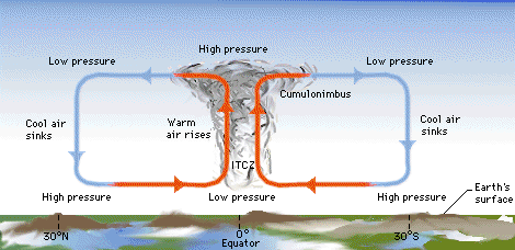
Africa straddles the equator, and its climate is largely determined by movement of the Intertropical Convergence Zone (ITCZ). This band is situated between two large atmospheric overturning circulations in either hemisphere: the Hadley Cells. These are driven by the differential heating of the planet. Where solar radiation concentrates at the equator, warm, moist air is forced to rise. As air rises and starts moving polewards, it cools and loses moisture, bringing seasonal rain to the tropics. The dry, cooler air then sinks, creating high pressure at the subtropics, which consequently forms 'Subtropical Dry Zones', where Earth's major deserts are found.

The Hadley Circulation and formation of the ITCZ between the two cells (Source)

This large low pressure rain band doesn't stay put for long, migrating south of the equator during the Northern Hemisphere (NH) winter, and shifting north of the equator during NH summer. African countries sitting between the ITCZ's annual path are blessed with rain throughout much of the year (e.g. Democratic Republic of Congo). However, countries which only greet the ITCZ once a year (e.g. Sudan) have just one deluge. Put simply, countries lying between the ITCZ's extent of movement are generally humid, and countries outside of that area are semi-arid or arid. The ITCZ is therefore vital in controlling the temporal and spatial distribution of precipitation across the continent.


Annual migration of the ITCZ (Source)

Global climate change is a very real and imminent threat to Africa's population, ecosystems and water resources (Carter and Parker 2009). Evidence is constantly growing to show anthropogenic warming has increased over the last century, particularly over parts of the arid African continent, where surface temperatures have risen by 0.5°C in the last 50-100 years (Niang et al 2014). The Intergovernmental Panel on Climate Change (IPCC) Fifth Assessment Report (AR5) suggests that towards the end of this century heat waves will increase, droughts will intensify, and extreme precipitation events will become more common (Niang et al 2014). Under a high emissions scenario (RCP 8.5) it is possible that Africa could warm by 3-6°C by the end of the 21st century (Niang et al 2014)! A temperature rise of that magnitude, though uncertain in probability, would seriously exacerbate existing water stresses.

The Clausius-Clapeyron relation demonstrates that as temperatures rise in a warmer world, the atmosphere can hold more moisture, hence the global hydrological cycle will intensify. Durack et al (2012) predict this intensification could be as much as 24% in a world warmed by 2-3°C. This would mean more extreme heavy downpour events, with fewer low-medium intensity events (Allan and Soden 2008). The general rule of thumb is the 'wet gets wetter, and the dry gets drier'. Dry North and Southern Africa are predicted to experience reduced rainfall, whilst relatively humid West and East Africa may experience more intense wet seasons (Niang et al 2014). For countries like South Africa, climate change could cause the loss of perennial (year round) water supply (de Wit and Stankiewicz 2006). Regional and local aspects of climate change in Africa mustn't be overlooked - hydroclimatic changes are not uniform across the continent!

There are MANY more consequences of climate change on various water resources in Africa that cannot be covered in this one introductory post. This is just the tip of the iceberg (excuse the pun). For now, it is important to recognise that climate change threatens to disrupt the rhythm African people have become accustomed to. Entire livelihoods can be based on one seasonal flood. If that flood doesn't happen in a warmer, uncertain future, crops will fail, livestock will starve, farmers will lose money, and Africa's taps might just run dry.

For more in depth information and a really good insight into climate change and policy in Africa, I recommend reading Chapter 22: Africa, in the IPCC's AR5 WG2 report - aka Niang et al (2014).

Tuesday, 13 October 2015

This is only the beginning...

Hello world, and welcome to my blog. Despite having experience with other forms of social media, this is the first (daunting, but exciting) time I have entered the blogosphere. So, what am I doing here? Over the course of the next 3 months I will be exploring the complex relationship between climate change and water in the continent of Africa.


Water is the essence of life. We humans can only survive 3 days without it. It is a fundamental element, not only for domestic use, but also for industry and agriculture. Climate change means that the things we have become accustomed to and take for granted, may be on the brink of drastic distortion, or even extinction! This is a pressing issue which requires immediate global attention to avoid putting millions of lives at risk. I care, and so should you.

Throughout this journey I will be investigating a broad range of topics including (but not limiting myself to) changes to existing weather patterns, impacts on water supply and quality, and impacts on agriculture, health and ecosystems. The distribution, supply, and access of water in Africa may notably change as we move into an uncertain, warmer future. As a physical geographer with a passion for all things climate-related, I will focus mostly on the physical science of the matter, but I will also address the social and political implications. Rather than adopting a strict agenda, I intend to go with the flow (pun intended) and follow my evolving interests as the blog and surrounding literature develops.


In my next post I will be delving into the depths of climate change, sorting fact from fiction, and specifically exploring the current water situation in Africa.

In the mean time, check out the short video below which sets the scene for some of the main features I'll be covering over the next few months.