After a long
deliberation, I've decided to narrow down the direction of this blog a tad. As you all know,
Africa is an enormous continent and thus its climate is hugely varied (see my earlier post), as are the effects of climate change on water resources. For these reasons,
over the remaining few months of my blogging journey, I'll be focusing purely on the climate change impacts on water resources (groundwater, surface
water, rainfall, glacial melt) in East Africa.
The 12 countries
included under the umbrella term of 'East Africa' according to the FAO include: Bostwana, Ethiopia, Kenya,
Malawi, Swaziland, Madagascar, Mozambique, Sudan, Tanzania, Uganda, Zambia and
Zimbabwe. The UN, however, also recognise Burundi, Rwanda, Djibouti, Eritrea, Somali, Comoros, Mauritius, Seychelles, Reunion, and Mayotte as part of East Africa. Quite a few countries, eh? I somehow don't think I'll be short of
things to talk about in my blogging!
 |
| Most of the countries which make up East Africa (depending on political or geographical groupings), with capital cities listed. (Source) |
Much of East Africa
is characterised by tectonic rifting, and this largely determines the hydroclimatology
of the region. For example, long, linear, deep lakes have been created due to rifting, such as Lake
Malawi. This tectonic activity has also made East Africa home to Mount Kilimanjaro
and Mount Kenya - two of the tallest peaks in Africa with unique equatorial glacial alpine
environments. Also found in East Africa is Lake Victoria (see map below), the world's largest
tropical lake, and second largest freshwater lake by surface area.
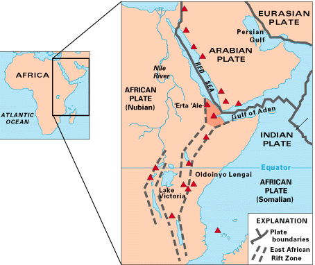 |
| Map of the East African Rift System (EARS) showing historically active volcanoes (red triangles) and the tectonic plates involved in the rifting. (Source) |
Considering its
equatorial latitude, parts of East Africa are surprisingly cool and dry. The reason for this is due to a rain shadow effect experienced on the leeward side of areas of high relief (e.g. Ethiopian Highlands and Rwenzori Mountains). Lets quickly recap what a rain shadow
is: warm, moist air is forced to rise up mountains/highlands, this air cools,
condenses and can no longer retain its moisture, so precipitation is induced on the windward
side under low pressure. As this drier, cooler air continues crossing the
mountain/highland, and starts sinking on the leeward side, it warms and creates
high pressure (and, thus a dry climate). Voila! This explains why parts of East
Africa, such as the Horn of Africa, experience increased aridity from topographic barriers.
 |
| The rain shadow effect, commonly found in areas of high elevation in East Africa. (Source) |
Just to briefly summarise what the climate change impacts are on East Africa, the wet seasons will
get wetter, and the dry seasons will become drier. This rule of thumb is true for much
of our understanding of generic changing precipitation patterns under climate
change. In East Africa specifically, there is high confidence in a projected increase in more frequent, but sporadic, extreme precipitation events (Niang et al 2014; Seneviratne et al 2012). Overall, this equates to more intense wet seasons in the future (Niang et al 2014).
That's all for now,
folks. Next time I'll be assessing how some glacial environments in East Africa are already dramatically changing as we move into a warming world.
No comments:
Post a Comment